

We are all aware of the terrible floods that have affected large parts of New South Wales in recent years – and have been repeated again this autumn in many of the same locations. As El Nino continues to deal its hand, Sydney suburbs like Illawara along the Hawkesbury-Nepean River were hit hard in April. In the Sydney region, 60 homes were evacuated and 17 rendered uninhabitable.
Hawkesbury has been badly affected by flooding seven times in the last four years and the pattern continues here and in other vulnerable parts of the state – repeated flooding blighting suburbs, insurers increasingly wary of recovery costs and the prospect of cover becoming prohibitively expensive.
The East Coast River flooding of 2022 remains the peak of claims to date, with costs estimated in the region of AUD 9.6 Billion, after some 240,000 claims were submitted between January and October of that year.
The ongoing 2022 Government Flood Claims Inquiry has heard how long and painful the claims and repair process has been and the important and urgent need for home buyers and owners to get better information about the extent of the risk they face and consider how they could mitigate against it.
By 2050, the average cost to each property in flood prone areas could be as high as AUD 45,000.
So all of this should be front of mind when clients are looking at property – but it’s important that they get access to this information which is now readily available from sources that are using more sophisticated predictive climate modelling. And this means making sure it is accurate for now and into the future.
The main problem though is that conveyancers and their clients have relied on Local Government provided information on flood risk in the 10.7 Certificate.
The 10.7 section 2 has been relied on for land zoning, permissible and prohibited land uses, details of exempt and complying development, controls for development or environmental hazards, as underpinned by Schedule 4 of the Environmental Planning and Assessment Regulation 2000. This has included flood and bushfire risk information derived from the council’s own zoning assessment of the risk.
In a previous e-book, we have demonstrated examples where the 10.7 (2) analysis for bushfire risk has been found wanting and highlighted some inaccuracies based on the zoning, the need to account for topography and future climate change.
And the same is true when it comes to Local Councils’ assessment of flood risk.
10.7 Flood data is modelled uniquely by that Council and there is no consistency between Councils on the method by which they do this – so one council’s appreciation of flood risk may vary considerably from another.
Often, there is no consistency between areas within the same council – they may use different input parameters, such as frequency of flooding event (return period) or estimated depth, which can dramatically change the risk profile and potential exposure of property,
Perhaps most importantly, the 10.7 (2) flood risk does not account for climate change and is based on past events that give no guide to how things could evolve in the future. Are the 2022 Eastern River floods the worst that will ever be? Our climate is getting hotter and wetter and more extreme. What about the lifetime of owning the property? Our climate is dynamic and data should never just look at what’s happened in the past as a guide to the future.
Equally, the 10.7 (2) flood risk also tends to be overly conservative and highly risk averse. It often shows the extent of Probable Maximum Flood (an incredibly extreme event) which could unnecessarily blight properties, create doubt for the lender and impact on the availability of affordable insurance.
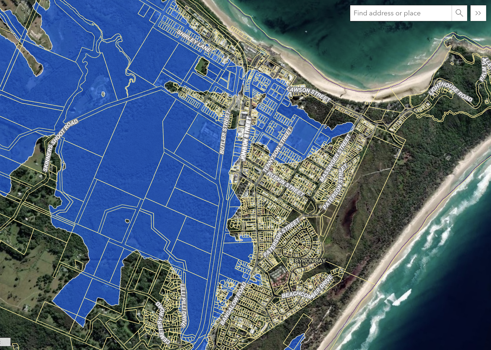
Image from Byron Shire Council Web Map, showing Council modelled flood extent. Map and satellite data powered by Esri, Geoscience Australia, NASA, NGA, USGS | Esri Community Maps Contributors, Department of Resources, Dept.of Environment and Science, Esri, TomTom, Garmin, Foursquare, METI/NASA, USGS |
In the above example in Byron Bay, the flood zoning identified in the Council Webmap is what is applied in the 10.7 (2). It covers a wide area that includes properties in the Tennyson Street and Lawson Street areas. We identified specific properties in Carlyle Street in the heart of this area and the 10.7 (2) identifies them as being at risk of flooding.
However, we ran this same location through our ClimateIndex™ analysis module and we identified that this area was likely to stay drier and have less of a flood risk now and into the future. This is important because it enables the homebuyer to proceed with more confidence whereas the 10.7 may have blocked the path to completion or given an unduly pessimistic view.
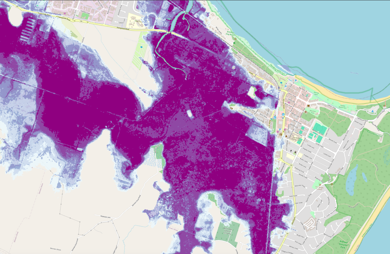
Image from Groundsure’s ClimateIndex™ flood risk analysis for Byron Bay, identifying reduced risk east of Jonson Street
ClimateIndex™ provides a consistent approach across all parts of New South Wales. It takes a current view of risk, built on past events and extents and then translates this into 5 and 30 year projections, based on a defined Representative Concentration Pathway (RCP) that shows the modelled rate of warming.
Our flood analysis is built from trusted third party sources to show undefended flood risk , which meets criteria specified by us on the likelihood (return periods) and severity (flood depths) for 1 in 20, 1 in 100 and 1 in 500 year events. Additional data on flood defences has been included by us to show where suburbs could be mitigated against the risk of flooding where defences are present and data is available, based on likelihood (return period). We have also developed a proprietary calculator to provide an assessment to the whole lot from flooding.
The consistency is perhaps the most important point when it comes to reliance in a conveyancing transaction. You want to ensure that your client can rely on a clear view of flood risk not just now but for the whole time they will own the property.
So for Byron Bay, our CimateIndex™ analysis suggests that even casting ahead 30 years, the flood extent, based on the current RCP projection, the Carlyle Road and surrounding areas are still unlikely to flood.
This gives you and your firm more confidence in advising your client on climate risk and fulfilling your duty of care, as explained in the NSW Law Society Guidance.
The ClimateIndex™ Report is available now on the Trisearch and InfoTrack platforms which include alerts to show the proximity of the property to potential climate risks, that also include bushfire and coastal erosion. For more information, contact us at info@groundsure.com or speak to your InfoTrack or Trisearch account manager.